Here's something that should make you sit up and pay attention: researchers have just discovered that nearly every major study about rising sea levels has been getting the math catastrophically wrong. And if you're planning trips to coastal destinations, this matters more than you might think.
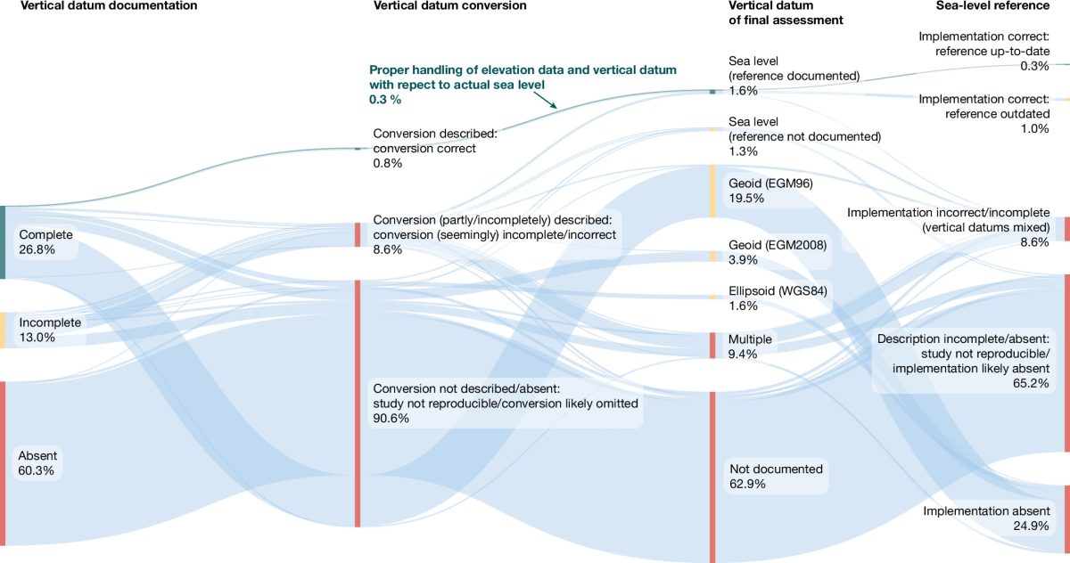
Scientists from Wageningen University in the Netherlands analyzed nearly 400 peer-reviewed studies published between 2009 and 2025 on sea-level rise. Their conclusion? About 90% of them were built on fundamentally broken data. This isn't a small margin of error. This is the kind of mistake that changes everything about how we understand coastal risk.
The Measurement Problem No One Caught
The issue comes down to how scientists measure sea levels. Most hazard assessments rely on something called geoid models, which are theoretical mathematical representations of ocean surface height. The problem is that these models aren't the same as actual, measured sea levels. The ocean doesn't behave like a math equation. It responds to winds, currents, temperature, salt content, and dozens of other variables that geoid models simply don't account for.
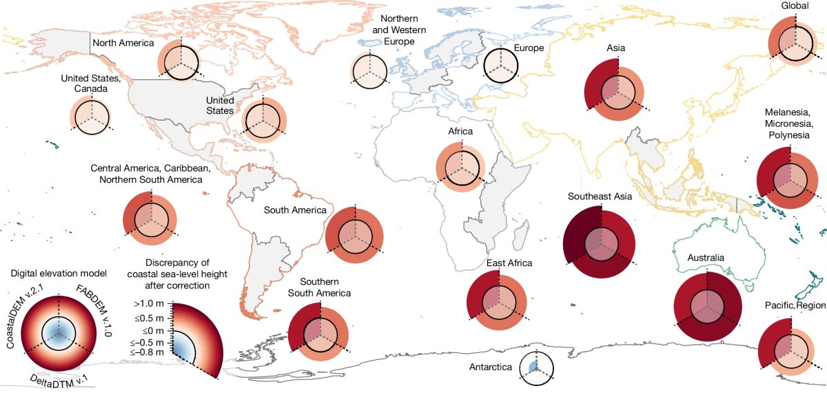
When researchers compared what the models predicted versus what tide gauges actually measured, they found discrepancies averaging 24 to 27 centimeters. In parts of the Global South, the gap ballooned to over 100 centimeters. Some areas showed underestimations exceeding 550 to 760 centimeters. That's not a rounding error. That's a fundamental recalculation of how fast water is rising.
Why This Changes Everything for Coastal Cities
The practical consequences are staggering. If flood risk assessments have been underestimating sea levels by this much, then the timelines for when coastal cities will face serious problems are also wrong. Cities that thought they had decades to prepare might need to act within years. Island nations that were planning adaptation strategies based on late-century projections might now be facing those same scenarios in the 2040s or 2050s.
This research suggests that major climate reports, including the UN's own Intergovernmental Panel on Climate Change projections, may need revision. The IPCC predicted sea levels could rise between 28 and 100 centimeters by 2100. But if the baseline measurements have been off by 24 to 27 centimeters already, the actual rise could happen faster and hit harder than those estimates suggest.
What This Means for Travel
For travelers and tourism operators, the implications are real. Popular beach destinations, port cities, and island getaways may need to accelerate infrastructure changes sooner than planned. Some places might face sudden shifts in accessibility or safety that weren't on anyone's radar just months ago. Hotels built near sea level in vulnerable regions could become risky investments. Cruise itineraries to low-lying ports might require rerouting faster than expected.
The good news is that this research is forcing a necessary reckoning. Instead of continuing with faulty models, governments and scientists will now need to conduct proper re-evaluations using actual measured sea-level data rather than theoretical approximations. That means better predictions, more honest timelines, and the chance to actually prepare cities before disaster hits.
For travelers, this is a reminder that coastal destinations should be on your list sooner rather than later if they matter to you. Venice, the Maldives, Miami, and countless other low-lying places remain spectacular, but their future is precarious. The scientific community is finally being forced to take the problem seriously. The question is whether policy makers will move fast enough to match the urgency.